Geological Survey of Canada and William Logan,1842
In 1842, the Province of Canada named geologist William Logan the founding director of the GSC, to map minerals and resources. It was to be a short-term task.
Few maps and surveys were available in 1841’s Province of Canada. The areas of Ontario and Quebec were thought to be rich in minerals and coal, but were they? A geologist was needed, and William Logan happened to be in Montreal at the time. He was the perfect candidate for the job, and he was interested.
Born in 1798 in Montreal, Quebec, William Edmond Logan moved to Scotland where he attended Edinburgh University for one year. The young man then took a post with his uncle’s counting-house firm in London, England. Taking over the management of his uncle’s copper-smelting works in Swansea, South Wales, Logan learned much about the geology of coal, coal mining and processing of ore, said Natural Resources Canada. On the passing of his uncle in 1838, Logan left the copper mining business and found time to nurture his growing skill in geological research.
Director of the GSC
Returning to Montreal for a visit, Logan caught wind of the need for a geological survey in the Province of Canada. He put his name in contention for the job. With his background and excellent recommendations from England’s science community, Logan was named the first director of the Geological Survey of Canada on April 14, 1842. The job was to be of short duration, perhaps only a few years. The first goal was to discover the location of coal to aid advancement of industrial technology.
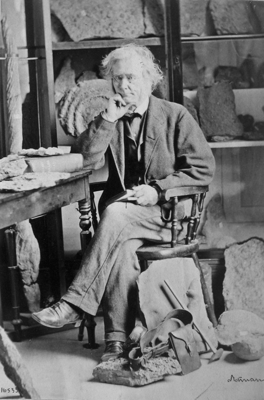
First director of Geologic Survey of Canada, William E. Logan sitting in his office. William Notman photography 1865/McCord Museum I-16533
Given a small budget of £1,500, Logan and his colleague, Alexander Murray, covered much terrain on foot, each man taking a different region. They did not find coal in Upper or Lower Canada, noting that “all the rocks it contained were older than the earliest known coal-bearing formations.” Instead, Logan found limestone beds from Montreal to Lake Huron, folded rocks in eastern Quebec and a large bed of crystalline rocks that would later be named the Canadian Shield. The budget was insufficient for the work required, so by 1844, Logan had already added £800 of his own money to complete the job.
First Scientific Staff Hired
Seeing that the mission was not finished, the government renewed the mandate of the GSC, infusing £2,000 into the budget in 1845. Turning down a position in India, Logan stayed on in Canada to guide the Survey. With the enlarged budget, he was able to hire chemist, T. Sterry Hunt, paleontologist, Elkanah Billings and draftsman Robert Barlow, plus support staff for the office in Montreal. Logan also opened a museum to display the rocks and minerals collected by Survey members.
Surveying the rugged Canadian topography was not an easy physical task. In 1843, Logan made note that, “I came to a place in the course of my scramble… where I found myself stopped by the water, and it is very tedious and great expense of time to clamber up the cliff”. Instead, according to Collections Canada, he took off his boots and socks, then his pants and drawers, and waded across not one but three watery areas. Logan kept excellent records, mapping, sketching, painting and recording all details of the regions he covered.
Logan was required to file annual reports to the government on the progress of the GSC. He argued that it was not appropriate “to expect annual reports from a properly-conducted geological survey,” noted Brian Shipley in a Dalhousie University paper. But reports were required and Logan acquiesced.
Pinnacle of Scientific Publishing
Published first with other governmental reports then separately, by 1863 Logan’s annual report became a valued source of geological information of Canada. The 963-page book was entitled “Geological Survey of Canada: Report of Progress From Its Commencement to 1863”. It included 498 woodcut illustrations, maps, fossil examinations and mineral discussions. The volume was “the pinnacle of Canadian scientific publishing in the 19th century,” said Shipley.
As Canada grew, so did the work for the Geological Survey of Canada. Nearing age 70, Logan decided to step down in 1869 after 27 years as director of the Survey, passing the helm to Alfred Selwyn of England. Selwyn was the director of the Geological Survey of Victoria, Australia before taking the post in Canada.
William Logan was knighted for his exacting work by Queen Victoria in 1856. Regarded as a top Canadian scientist who excelled in map-making, art and promotion of geology, Mount Logan in mountain was named in his honour – Mount Logan in Kluane National Park Reserve, southwestern Yukon. A century later in 1966, a mineral found in the Montreal region was named for the famed geologist, called Weloganite. Sir William Logan died in Wales in 1875 at age 77.
The main office of the Geological Survey of Canada is located in Ottawa, Ontario, with other offices scattered across the country. Reading the Rocks by Morris Zaslow is a fascinating look at the history of the GSC and its people, published by Macmillan of Canada, 1975.

Published by Morris Zaslow by Macmillan of Canada in 1975, Reading the Rocks is a fascinating delve into the history of the Geological Survey of Canada. It is a treasure.
This article first appeared on Suite101.com in October 2008. (C) Susanna McLeod